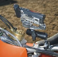
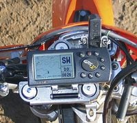
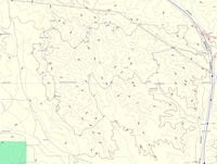
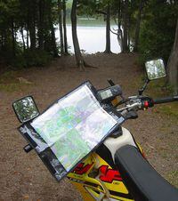
For off-road exploring, the Global Position System has changed the off-road world. The ability to know your precise location is obviously valuable in remote places. More importantly for off-road navigators, the ability to load GPS units with topographical maps makes navigation relatively easy. GPS units also allow you to create a track log, that is, record your precise route in the unit and then download it to a computer. That track log can then be loaded into other GPS units, and people can easily retrace your path.Organized dual-sport rides, in particular, are offering GPS tracks as a simpler alternative to route charts. Once you load in a "track," you can follow it on your GPS unit fairly simply. If you get off-track, the unit shows the direction to get back on track. You can still get lost with a GPS unit but they have made life for off-road explorers much simpler.We tested the Garmin GPS V, the model perhaps best suited to off-road motorcycling - it is small enough not to be cumbersome when mounted and it has top-of-the-line features. The GPS V comes with a MapSource base map loaded for North and South America. This means major roads and highways are shown on the unit, as well as waysides and in more populated areas, gas stations and other services. The unit has 19 megabytes of memory for loading more detailed topographical maps on the unit. The unit is waterproof and powered by four AA batteries, which offer a claimed 25 hours of power (though in actual continual use it only lasted 10-15 hours on alkaline batteries). Using the GPS V is fairly intuitive. The basic screen shows a map that you can zoom in and zoom out, with a bar of indicators on the right letting you know how far to the next waypoint and your final destination. Other screens display current latitude and longitude, speed, direction, and elevation.Mounting the unit can be done a couple of ways. If your bike has a battery, the basic RAM Mount for the GPS V is ideal. These units are simple, cheap ($40 or so), and either attach to your bike with u-bolt that fastens to the handlebar or a ball mount that is bolted to your triple clamps. If you don't have the unit hardwired to your bike's electrical system, the GPS unit will shut off when you hit bumps. I found this particularly annoying on a ride in Northern Wisconsin, as we kept losing our track logs. The solution is to hardwire the unit to your battery. I've used hardwired units on and off the road, and never had any problems with it shutting off unintentionally.If you don't have a battery, CycoActive recommends taping the batteries, using dielectric grease and using a high-tech off-road mount built by TouraTech. These mounts are considerably more expensive than the RAM Mounts (around $150 for the Super MGV shock isolated unit shown), but offer much better vibration isolation. I wouldn't recommend the more expensive mount for dual-sports, as we've had good luck with hard-wiring the GPS unit and using the RAM Mount. For off-road bikes without batteries, the TouraTech mount is the way to go.We used the DR 24 Hour as the initial step of the test of a GPS V mounted to the robust TouraTech Super MGV shock. One of the first trials we put ours through was to map the course that we used for 2004, including the "hard" loop. The map was the product of that measuring; not an easy feat, but possible with this unit. It was a good education on the abilities and limitations of the device.If you have lots of buddies with saved GPS tracks or intend to attend some of the GPS-tracked dual-sport rides, using the GPS V is a snap. Download the tracks, page to the screen that shows the map, and zoom into the proper view (the 0.8m view works good for most situations). The readouts on the right show you how far to the next turn, and the unit estimates time to next turn and time to final destination.If you are using the GPS V in unmapped territory, you have a number of options. First off, don't think a GPS unit is a substitute for a good map! Along with a great map, it's ideal. The map gives you the big picture, and the GPS unit pinpoints your location and tracks your route.On marked roads, the built-in maps will give you an idea of where you are. This feature is only useful when riding near numbered highways and roads. Most gravel roads do not appear on the base map. As these roads are the best for dual sporting, the base map doesn't really help on most dual-sport rides, and is only useful for getting your bearings when riding off-road.For serious backcountry, loading topographical (Topo) maps is the hot set-up. These show you precisely where you are by giving landmarks. You can find lakes, rivers, and high points on the GPS unit and figure out your position. We like to use the loaded maps along with a nice topographical printed map. That way, you can zoom in, see that you are in between, say, this lake and that high point, and use the map to pinpoint your location.One of the most useful features is the Go To function on the GPS V. You can select a waypoint, town or other landmark, and chose the Go To command. The unit then pulls up a screen that displays a large arrow which points toward the destination, and a digital readout that displays distance to the point.Note: The GPS V Go To feature only works with the built in base map data or special Garmin MapSource CitySelect downloadable map data ($130 for the North America map set). Topo maps do not contain sufficient information for the GPS V to calculate GoTo routes, but standard waypoint navigation and trail track running is still possible.On the road, the unit can also draw maps using the highway system. I tested this in my truck and found it's great in more populated areas but less useful in rural areas where the built-in base map's limited coverage of smaller highways shows up (MapSource downloads solve this dilemma for most areas of the U.S.). Unfortunately, at the moment MapSource is a PC only software product.However, Mac users are getting more options to use GPS software. Until just recently, the only way to load maps and routes on or off a GPS unit with a Macintosh was by using expensive PC emulation software, which by most reports worked erratically. Well, Mac users can now try a software package from James Associates. You need to purchase the software package (about $40) and an adapter ($45) to hook up the PC cable to your Macintosh. Mac owners also have options to use computer-based topographical maps. National Geographic Maps offers most of the U.S. states in Mac format. With these two options, there is hope for the Mac faithful of the world. Might save me from having to buy a beater PC just for GPS loads!A note about GPS accuracy: Recently, the US Government removed special accuracy inhibiting security features from the GPS network. This has allowed most commercial GPS receivers to remain accurate to almost 20 feet with near-perfect signal reception. Accuracy depends heavily on the quality of the received GPS signals (trees, hills, rain and other common off-road features can have drastic effects on GPS quality). When attempting to collect route data or to follow routes, be aware that the accuracy differences can add up to well over 100ft of offset. In tight woods, this can very easily send you off onto the wrong trail if you aren't keeping a close eye on the characteristics of the trail such as corresponding turns and even altitude. For most situations, the accuracy effects won't reduce your enjoyment, but it can be frustrating when things don't match exactly.Additionally, most GPS trail plots are not stored at a resolution sufficient to capture every small turn in typical trails. This is caused by two factors: The first being the rate at which the original trail plotting was taken (A lower update rate or longer distance between update points may miss turns completely). The second being that many GPS units will compress the trail data by removing plot points. The methods used to compress vary among GPS types and are too complicated to discuss here. For example, the GPS V will plot trails in what's known as the Active Log at the user's selected update rates. But when the data is saved, due to the limited memory available for the Active Log, the GPS V will compress the data (this was an undocumented "feature" and is the sole reason the 24 Hour map doesn't show very many of the tight corners we assure you did exist). It pays to be wary of the data you see on your GPS!-Lee Klancher and Robert JordanDR Rating: 9.0Sources:CycoActive, Inc.: 800/491-2926; www.cycoactive.com Cycoactive has lots of good information about GPS units and sells GPS units, RAM mounts, Touratech Mounts, and other mapping accessories.Garmin: 800/800-1020, www.garmin.com Web site great for info on specific units and for purchasing mapping software and accessories; the GPS units are sold at dealers.National Geographic Map Store: 800/962-1643; www.trailsillustrated.com Topographical mapping software that works well with GPS units; has line of mapping software that is Macintosh compatibleJames Associates: 303/258-0576; www.macgpspro.com Sells GPS units, Macintosh software that interfaces with GPS units, and Mac-ready topographical maps.GPS Information.net: www.gpsinformation.net This Web site offers great information about buying GPS units, along with detailed reviews of different units, software, and accessories.
/cloudfront-us-east-1.images.arcpublishing.com/octane/OFSXJJ5PZFEZ5D5ZPMCFVHJUMA.jpg)
/cloudfront-us-east-1.images.arcpublishing.com/octane/N2JLNLG44VEKBMEPORRDTMX5A4.jpg)
/cloudfront-us-east-1.images.arcpublishing.com/octane/EOERU244ONEWVKQ7C24OHMRVWY.jpg)
/cloudfront-us-east-1.images.arcpublishing.com/octane/JF4T3ULTGNHTVEKSTNKLJ2IGKY.jpg)

/cloudfront-us-east-1.images.arcpublishing.com/octane/FAOZEEEXFVA3ZK2PYMY3DHI2EQ.jpg)
/cloudfront-us-east-1.images.arcpublishing.com/octane/WCAUGYKA5FDZTB64FM36LJFMMM.jpg)
/cloudfront-us-east-1.images.arcpublishing.com/octane/EIDVOIN5IJDMRIVS2VNTOOBVSA.jpg)
/cloudfront-us-east-1.images.arcpublishing.com/octane/5BSWCTPONFB3DJFRPJ34STZMR4.jpg)
/cloudfront-us-east-1.images.arcpublishing.com/octane/KSERUHQUTNHLBCWKXS2R3TYZHI.jpg)
/cloudfront-us-east-1.images.arcpublishing.com/octane/GGOH2AQRSVHY5C5JLNEVYLB5SU.jpg)
/cloudfront-us-east-1.images.arcpublishing.com/octane/TJJEHV3ATZFFXHUYZABHXKE2DI.jpg)
/cloudfront-us-east-1.images.arcpublishing.com/octane/M7L5LNQ5JZENHNBTCHEIKZKD24.jpg)
/cloudfront-us-east-1.images.arcpublishing.com/octane/WIC4RXQ36BAXNIW6U4UJ3XDLKI.jpg)
/cloudfront-us-east-1.images.arcpublishing.com/octane/G64JLSXQBJFMVPTETPM4H353EU.jpg)
/cloudfront-us-east-1.images.arcpublishing.com/octane/ZBMLCCOSNJBIVAEC2OU6YSONKY.jpg)
/cloudfront-us-east-1.images.arcpublishing.com/octane/U7PDRXGEI5DCFJGSVGNLAHGIMA.jpg)
/cloudfront-us-east-1.images.arcpublishing.com/octane/S553MV5QAJFOHGOKYO7TJ6NGYA.jpg)
/cloudfront-us-east-1.images.arcpublishing.com/octane/62WLA7IMLVF2LIPTA4DGILHZIM.jpg)
/cloudfront-us-east-1.images.arcpublishing.com/octane/BW6RDLNDENAVFHMPINCIIY3XCI.jpg)
/cloudfront-us-east-1.images.arcpublishing.com/octane/FEROGJTVONBBZKEUH46OD6R2VY.jpg)
/cloudfront-us-east-1.images.arcpublishing.com/octane/IFBSQJ2HCFG5JKH4GM3NB5LC3M.jpg)
/cloudfront-us-east-1.images.arcpublishing.com/octane/GPNWD73XDJDG7LMXDVFDZ7CL2I.jpg)
/cloudfront-us-east-1.images.arcpublishing.com/octane/BDI3FSQXIFAYHNC62TCPI3DV7E.jpg)